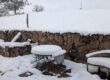
Moondo surveying his not-so-snowy domain on Christmas Eve.
Weather here defies pattern-seeking. High elevation and dynamic terrain make fickleness, with a propensity for the extreme, the norm. Sure, there are thunderstorms in summer, but their duration, ferocity, and direction of approach keep me guessing. The same can be said of wind, except it will kick up whenever the heck it wants to. Snow is slightly more predictable. Although possible any month of the year, it can be expected any time from November through May, and you’d be advised to be prepared for its arrival by the second week of October.
This past fall, the snow never bothered to show up, other than an inch here and half an inch there. Dry weather crisped the grass, unleashed the dust, and stirred the sort of anxiety that I recognized from years of drought. When I fretted to neighbors about the dry weather, though, several of them exclaimed in protest: “But we had such a wet summer!”

Delicate sego-lilies blooming in July.
By certain measures, that’s true enough. Late winter snows, falling in April and May as the ground was already thawing out and ready to receive moisture, brought on an early season green-up the likes of which we haven’t seen in recent memory. I’d evidently gotten used to the grass not breaking dormancy until late June, because I just could not get over that flush of early springtime verdure: so green! so soon!! Thunderstorms arrived on schedule in July and August, and the grasses and wildflowers kept their momentum. Sego-lilies bloomed for the first time in years. The horses got fat. I think everyone in the area luxuriated in a summer that was largely free from concerns about forest fires.
All of which makes it very weird to know that our local precipitation for June/July/August 2014 was 3.22 inches less than those same months in 2013, when things were crunchy and fire-prone.

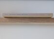
The NWS rain gauge captures snow as well as rain. In summer, precipitation is funneled into a measuring tube that fits inside the can. In winter, snow that falls into the can is melted and then measured.
I’m able to trot out a statistic of such precision because of the really big rain gauge that sits in front of our barn. I’ve been part the Cooperative Observer Program of the National Weather Service (NWS) since late 2008. As part of my five o’clock horse-feeding routine, I record data on 24-hour precipitation accumulations and high/low temperatures.
Minding the weather fits nicely with my predilection for gathering up small details about my home place, although formal data-gathering demands that I be more disciplined and systematic than is my usual habit. The obligation to take down information for someone else—and in numerical form—represents a different perspective than the casual watching I specialize in, and provides an interesting reality check. I’m never surprised when I look back at a data sheet and discover I’ve mis-remembered how wet or windy or hot a month was: that my brain is not reliable is why I write.
But the weather records also invite consideration of factors that might not have occurred to me otherwise. In looking back at the more-than-three-inch disparity between one summer’s wet “dry” and the next summer’s less wet “wet,” for example, the data pages show that there were more days with less than a tenth of an inch of rain in 2013 than there were this year. In summer heat, moisture from such brief showers is more apt to evaporate than to soak in.
 Later, though, in September 2013, the same weather system that caused massive flooding around Boulder dropped 2.38 inches of rain into the gauge. Since I was here, watching and not just recording numbers, I know that our precipitation consisted of slow rain and mist, conditions that helped send water deeper into the still-parched soil column. Coming on the heels of an improved summer monsoon and in advance of a somewhat snowier winter, then fed by a second year of decent summer rains, the effects of that old precipitation were still visible a year later, in tawny ripples of grass ripening on the slopes hereabouts.
After paltry snowfall in October (0.5 inches) and November (3.2 inches), the big silver NWS can in front of the barn is getting a workout again, finally. The Christmas Night storm that dumped on other parts of Colorado gifted us with 3.4 inches of snow. That was soon followed by another 8 inches, carried in on a cold front (daytime high of -7 degrees on December 30). In the space of a few days, the four-month period of September through December of 2014, which was on track to be the second-driest in eight years, suddenly looks like it will end up merely on the low side of average. Ditto for the total precipitation 2014.
Fickle, but for this year, at least, avoiding the extreme.